Dark Sky Studio
Salt & Silt
Salt & Silt
The Scaur & Silt Series Map Collection
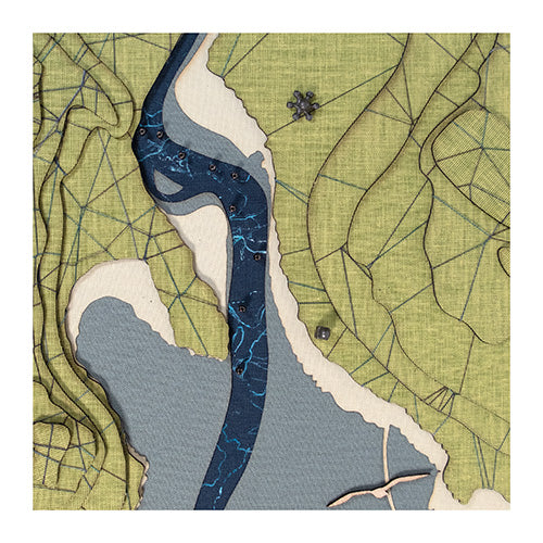
The River Urr winds its way through Dumfries and Galloway before meeting the sea at Rough Firth, where the village of Kippford hugs its tidal banks. Once known as Scaur, this small settlement grew from a cluster of 18th-century cottages into a maritime village, shaped by the Urr’s ever-changing flow. The river—narrow, winding, and rich in history—was once known as the "Winding Orr".
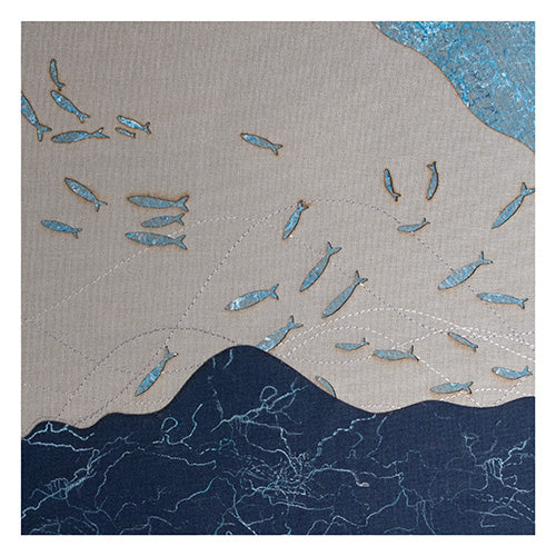
Deep-sea dark and serene, with green topography emerging like currents beneath the surface. Printed details and soft contrasts that ebb like the tide and etch memories of shell beaches and storm-cleared skies.
Features:
- Green topographical landscape embellished with dark blue basket weave stitch
- Steel blue mud flats
- Hand printed steel blue fabric representing the River Urr
- Freestyle machine embroidered blue tidal flows
- Light blue fish
- Rough Island represented in terracotta pebble.
- Yacht Club and Start hut are marked with 3D symbols.
- Plywood Seagulls
Hestan Island, situated off Torr point, is represented by green fabric island.
Encased in a 68cm X 28cm white painted wooden frame (4.5 cm deep), fitted with a durable cotton cord for secure wall display. This art map is hung vertically. Encased in a 68cm X 28cm white painted wooden frame (4.5 cm deep), fitted with two durable cotton cords for secure wall display.
The art maps offer versatile display options, allowing them to be hung or positioned in three different ways, vertically, horizontally, or freestanding. Each piece comes with two wooden support blocks, enabling a stable and stylish frees standing display.
Couldn't load pickup availability
Share